Fort Peck Dam, which was built to control floods, was constructed as a hydraulic earth fill dam and is still the world's largest built with this technique. It was built using 126,000,000 cubic yards of mud from the river bottom that was dredged and pumped to the site through miles of slurry pipe. This watery sludge was compacted and the water squeezed out by the weight of the next layer. It is almost four miles in length, 250 feet high, 2/3 of a mile wide at the base and 50 feet wide at the top. The project was not completed without major problems. On September 22, 1938 two weeks after the major work was done a quarter mile of the dam collapsed causing a two year delay. This disaster seemed to be the result of the rush to get the job done. The dam has been blocking the Missouri River for over 70 years so it appears to be working just fine.
To accomodate the huge influx of people, a whole new town, Fort Peck was built. Much of it remains today including the theatre where they have plays on summer weekends. There were also 18 boomtowns that sprung up to support the growing population.
The spillway (which keeps water from going over the top of the dam) is three miles from the dam. It has sixteen 75 ton gates that can be opened to lower the water in the lake. They have been used only five times, most recently in 2011 when the water nearly went over the top before the gates were opened. The spillway was pictured on the first cover of Life magazine and because of its size was misidentified as the dam.
This is looking from the bottom of the spillway. The concrete section is a mile long. When it is used, the spillway puts the water into the Missouri seven miles below the dam.
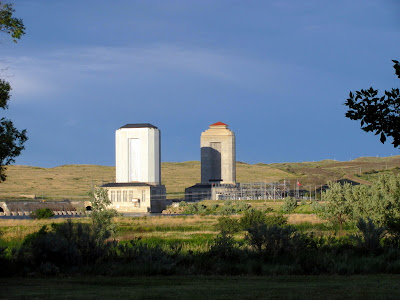
The first hydroelectric powerhouse was added in 1941 and the second in 1958. The towers hold open top surge tanks with water that is at the same level as the lake. The tour of the powerhouse was one of the best we have ever been on. First of all we were the only two on the tour so it was really personal. We were encouraged to lean against the side of the turbine generators so we could feel how much less the vibration is in the newer one. We were even allowed to touch the turning shaft that connected the water turbines to the generators. Much different than our tours of Hoover and Glen Canyon Dams. No pictures were allowed.
Left are two of the four outlet tunnels that carry all the water of the Missouri under the dam. The other two tunnels go into the powerhouses. All of the tunnels are more than a mile long and almost 25 feet in diameter. Each tunnel is designed to carry double the normal flow of the river.
The Interpretive Center not only has excellent exhibits on the dam's construction, but also a great display of fossils that were discovered during construction.
Two of the dinosaurs from the area. Fossils are still being discovered today.
Of course when you are on the Missouri in Montana you are where Lewis and Clark travelled on the Corps of Discovery.
Storm clouds above the plains below the dam where the Milk River flows into the Missouri. Lewis and Clark described this confluence in their journals.
It was the first day of summer during our visit, but spring was the season here for the many flowers in bloom and many birds chirping.
We did not visit Fort Peck on our 1982 bike trek so we took advantage of a beautiful day to bike across the dam and enjoy the views of the lake and surrounding land. There are few places where you can get to the 1500 mile shoreline without a boat.
I know this post has a lot of big numbers, but Fort Peck is a big, big place.


2 comments:
Beautiful post of one of our favotite places, and you did things we never even knew of!
Spent time there a few years ago. I, too, thought the history of the dam was fascinating. We saw a play about Will Rogers at the theater. Loved the area.
Post a Comment