Saturday, May 31, 2014

Day Three Alaska Hwy -- Liard River to Watson Lake

It was only 130 miles from Liard River to Watson Lake.  We can now add the Yukon to our travel map.  We have been in 11 of Canada's 13 provinces since going on the road. The drive offered more great scenic vistas and more wildlife.  There was a bit more traffic, but not really what I would call busy.  A couple of times I could see one vehicle ahead and one in the mirror.  It may be heavier after we leave Watson Lake as the Cassiar Highway meets the Alaska here.  We spent two days in Watson Lake, which apparently is not the norm because we were the only people in the campground by 10 AM.  By 5:00 in the afternoon there were about 25 rigs.

We have stayed in Campgrounds every night mainly to be able to plug in for power rather than running the generator during the cool mornings.  While the campgrounds have been very expensive we have had wifi at all but one, so I have been able to keep up to date with the world, not that it really matters. It does let me keep up with the blog so when the wifi is good I try to get a couple written.  At the Downtown RV Park in Watson Lake the connection was great yesterday when no one was there, but I could not get connected either evening when the place is packed.  At most of our other stops the connection has been good and unlimited.        
We had not gone five miles up the road from Liard River when we began seeing the wood bison.  Some were on the road, some in the grass and a few in the trees.  Bison are the largest mammals in North America and, while they appear to be calm and gentle while grazing, they are wild animals that can be very dangerous.  A big problem here is people hitting them while driving at night.  I can't imagine how much damage that would do. 
And of course more bears.  We stopped and this one gave us a good look before going back to eating.
I'm not sure, but this may be our first grizzly.  It was small and did not have that characteristic hump, but it was brown.  We have seen so many bears we have lost count.  We don't even slow down for a picture of every one and this is only our third day on the Alaska Highway.
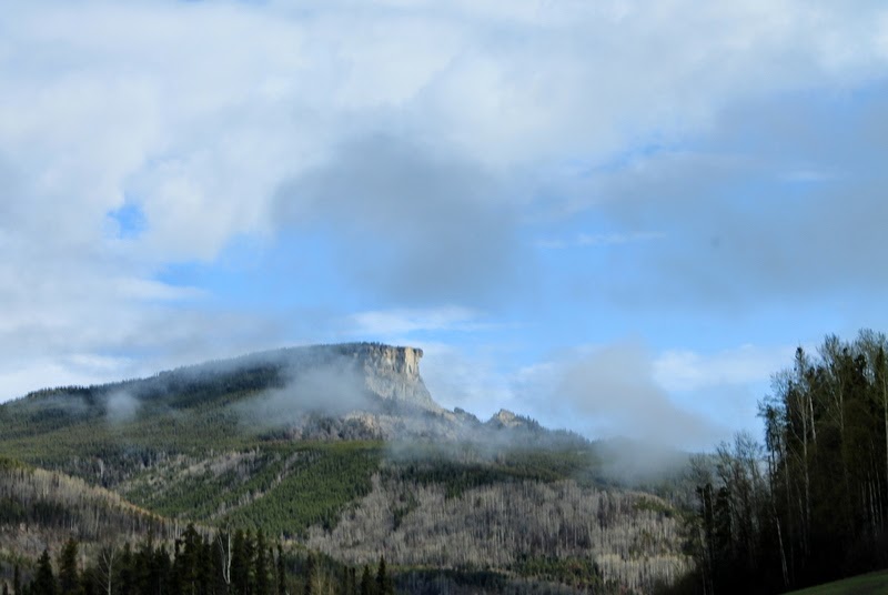
Typical of the days drive through Northern BC.  Rolling hills and a lot of trees.  
Most of the day we traveled along the Liard River.  After spending the winter in the arid Southwest it has been wonderful seeing all the trees and so much water.  All of the aspen leaves are out and the green is beautiful.  Spring is further along here than it was on the plains in Alberta where the leaves were not out. 
A typical crowded rest area.  This one even a had a toilet while most are just wide spots in the road with a trash can.
Blue sky, trees and blue water.
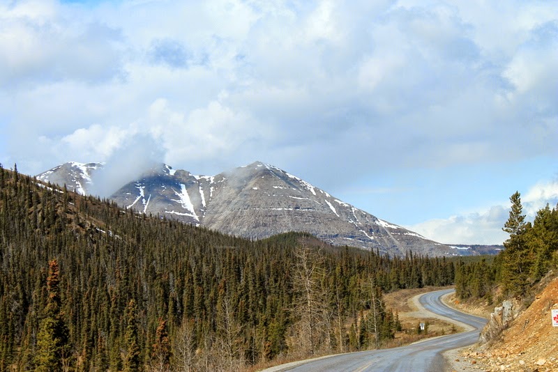
More mountains come into view.  They do a good job of keeping a wide area cleared on both sides of the road, which gives you a chance to slow down when you spot wildlife.
Watson Lake Motors was built of logs in 1953 to start serving travelers on the Alaska Highway after the ban on civilian travel was lifted.  It must have been some trip in the 1950's.  It was the largest repair shop north of Fort St. John a few hundred miles.
Watson Lake is famous for the Sign Forest that was started in 1942 when a soldier added his hometown to a signpost with the names of distant cities like New York, Pittsburgh, Chicago and Tokyo.  A tradition was started that continues to this day.
A few signs of places we know very well.  The Brooke High is for all our West Virigina family and friends who attended school there.  The others are Western PA towns near where we had our stix and brix.
We even found the sign that Mark and Renita put up for Betty two years ago.  We had planned to hang it but when our plans changed they did the job.  We sure do miss that place and Betty.
The latest total is over 78,000 and growing.  There are signs from around the world.  Makes me wonder how many of them were stolen as a great number of them are official road signs.
They even have some old highway equipment that worked on the road.
We are now forever immortalized in Watson Lake with our very own homemade, not stolen, Washington PA sign.
It is in the center on the outside row so if you are passing through Watson Lake see if you can find it.
What is a trip to the Yukon without seeing the Northern Lights.  They are just fantastic.  Actually, they are not seen in the summer because there is to much daylight.  We do recommend going to the local planetarium, the Northern Lights Center, for a great look at this beautiful phenomenon.  It will be much warmer than coming to see them in the winter.
Another new bird for us, a green winged teal.  We saw it on our walk on the nature path around Wye Lake.  Watson Lake is a must stop if you are driving the Alaska Highway.  Don't be like the couple we saw who just slowed down and took a picture from the car.  It is neat searching through the sign forest.

Thursday, May 29, 2014

Day Two Alaska Hwy -- Fort Nelson to Liard River

Our plan was to continue on up the highway after one night in Fort Nelson. We awoke to very cool temperatures, overcast skies and drizzle. The forecast was for improving weather and since the next day's drive was into the Rockies and over the highest point of the highway with the road being narrow and winding, we decided to just spend another day in Fort Nelson. This really reinforced our belief about not doing this trip with a commercial caravan with a set schedule (if it's Tuesday it must be Whitehorse) which would have had us driving this very scenic part of the trip through low clouds and fog, missing out on a fabulous day. That's why we like the Loosey Goosey group whose "set" schedule is, if you want to spend another day it's no problem, we will meet you up the road somewhere.   We wanted to have the best viewing conditions possible while driving a section that one guide book describes as the Serengeti on the north.  We drove 190 miles through some of the most beautiful country we have ever seen.
We were almost immediately rewarded for our patience when this mama bear and two cubs crossed the road. While they say you should not stop on the road to see animals, the total lack of traffic does not make this a problem. We stopped and watched as the bears went to the edge of the forest, turned to make sure we were not a threat and then ambled on. These were the first of many, many bears we saw this day.
As we started the climb through the foot hills the road narrowed and clouds hung low at the top of the first hill. We were optimistic that it was clearing as we could see patches of blue. We continue to marvel at the effort it took for those soldiers to build this road through the wilderness in 1942.
As we started down the other side the clouds cleared and we had a great view of Indian Head Mountain. At first I thought the Old Man of the Mountain that fell in Vermont had moved here.
By the time we reached Summit Lake, the highest point of the highway (4250 feet above sea level), the skies had cleared. While the lake was ice covered and there was some s**w on the ground, it is much less than I would have expected this far north, this time of year.  There is a great campground here if a stop fits your plans.
As you can see as soon as we were over the summit it was back to distant snow capped peaks and no snow along the road.
I can't emphasize enough the importance of having The Milepost guide book for important information about the road and exactly where you are going to see animals. This big Stone sheep ram was with a herd of about ten. It is amazing how close you can get.
Great mountain vistas and more animals.  I think this is an elk, but I'm not sure.  They are just starting to grow their antlers.
The folded mountain.  These mountains where once the bottom of an ancient sea with layers of sand turning to rocks over thousands of years.  As the Rockies were pushed up by the Pacific plate the layers folded.
The road crosses many alluvial fans, deposits of sediment that have been washed out of the mountains.  It sure lets you see the power of the spring melt.  When our friends Mark and Renita came through this area two years ago they were delayed for several days because a bridge had been washed out.  We crossed the replacement. 
More beautiful mountains.  The traffic continues to be very, very light.  I don't want to jinx us, but the road conditions have been fine the first couple of days.  Part of it may be that there is so much to see that we are only traveling about 50 mph most of the time.
Beautiful Muncho Lake is still ice covered.  The blue green color is caused by copper oxide in the water.  This was one of the more difficult sections of the highway to build with the roadway being carved like a shelf out of the mountain that went straight into the water.  
Another Stone sheep.  Really, the animals are everywhere and they are obviously used to the vehicles and people.  They warn against feeding them, which seems like a no brainer to us.
A first for us, the caribou.  You can see that the one has a very small rack that is just starting to grow.  Hope we get to see one with a big rack later in the summer.
More Stone sheep that did not care that they were standing by the highway and did not move even as we passed.
And we think we are on an adventure!  We did not get to talk to this guy, but he brought back memories of our cross country bike trek.  WOW!!!  What an awesome ride it would be to bike the Alaska Highway.
We did drive through some rain.  Here it was raining while there were blue skies just around the bend.  The only thing missing was a rainbow.  We pulled off the road and waited hoping to see one but it never developed.
The only remaining suspension bridge on the highway crosses the Liard River.  I'm sure it is in better shape than the one pictured in the last post.  When the highway was built in 1942 almost all the bridges were temporary wood structures that needed to be replaced because they were so low to the water they were often washed away.  The army turned the road over to the Public Roads Administration who built more permanent metal bridges in 1943.
As we left Fort Nelson a huge electronic sign warned of bison along the highway from Muncho Lake to the Yukon.  At first the only sign of bison we saw was miles and miles of chips.  Then we saw a couple and then more and more along and on the road.  We saw an information sign that said there are only 200 Wood Bison in BC.  If that is true, I think we saw most of them.   
Our day ended at Liard Hot Springs where we took advantage of the soothing waters and soaked our bones.  The hot springs has water as hot as 125 degrees as it enters the pool, but as it mixes with cooler water most of it is only about 108.  Very comfortable.
There are two pools of water with the upper one being the hottest and least crowded.  At the bottom right is the hottest spot.  Tradition says you should place a stone on the dividing wall to prove you made it into the hottest water.  Liard Hot Springs is not to be missed if you are making this trip.  Great if you are a weary road traveler.

Monday, May 26, 2014

Day One Alaska Hwy - Dawson Creek to Fort Nelson

One thing we have discovered already is the hours of daylight are getting longer very quickly even though we are still a month away from the summer solstice.  It is pretty much still daylight when we go to bed and when we get up.  In Dawson Creek the sun was up at 5:36 and set at 9:21.  After only one day on the highway to Fort Nelson sunrise is at 4:25 and sunset at 9:52.  Being people who love the dark it made it hard to fall asleep so I put cardboard between the blinds and the windows.  The bedroom is now like a cave all day.  Good for napping:-)


We knew the road to Fort Nelson would be in good shape with long straight stretches and just a few hills and curves so we drove 282 miles in one day.  I think this is the most we will do in a day until we start back to the lower 48 in August.  The day was mostly sunny but there was a swirling wind that seemed to be blowing from every direction, not fun in a motorhome.  Most of this section of the highway was a "old winter road" so not as much work was required as there was on the rest of the road.  There were still bridges to be built and widening it so large military vehicles could pass. 
The first real steep hill we encountered was going down to the Peace River near Taylor.  A 10% grade is about as steep as we have ever driven.  We geared down and used the engine brake to slowly descend.  Of course, what goes down must come back up so there was a good climb on the other side.
The latest of several bridges that crossed the Peace was built in 1960.  Three 1942 wood truss bridges were washed out by floods, so in 1943 a suspension bridge was built high above the water.  It was one of only two suspension bridges on the highway.
This is what happened to the suspension bridge in 1957.  Fortunately, a truck driver noticed that the cable anchors were coming loose and the bridge was shut down before it collapsed.
The memorial at Charlie Lake honors the 12 American soldiers who died here when, during stormy weather, the pontoon boat they were using to transport heavy equipment across the lake sank.  I missed the turn off so we did not get a close up picture.
We passed many of these camps along the way.  They are trailers that have been brought in to house the energy workers.  See if you can figure out which milepost is here from the name of the lodge.
All these signs are for different drilling company employees and loggers to find their way to work. 
After a few days on the plains we once again saw the snow capped Rockies.  We were surprised at how little snow there was on the peaks.
Typical of the first day's drive.  Miles and miles of forest and distant mountains that we will be crossing on the next leg.
There were several places along this section where the new road has been built over the years.  The highway is 35 miles shorter today than when it was completed in 1942.  This new section eliminated the second highest point, Trutch Mountain, and many curves, when the bypass was built in 1987.  You can tell from the signs that there is drilling going on in this area.  You can still drive some of these old sections, but they are not well maintained.
Click to enlarge and find the coyote.
There were many sections of the road without any lines.  It was fine during the day, but I would not want to drive it at night.  I was also surprised at there was so little traffic.  We sometimes went for miles without seeing another vehicle.  I don't know if that will be the case all the way north or not.  I hope so as it makes for a much easier drive.
Our first black bear of the trip.
And our first moose.
Another black bear.  We were told we would not see much wildlife during the day, which proved to not be true.  We are looking forward to seeing a lot more animals all summer.
This is the low point (1000 feet above sea level) of the highway where it crosses the Muskwa River near Fort Nelson.  The next leg of the journey will take us across the highest point when we cross the Rockies.