Wednesday, April 30, 2014

Inclement Weather Cramping Our Style!!

As I said in the last post we decided to go to Twin Falls, ID where we could have the clutch in the CRV repaired.  We arrived on Sunday with sunny skies, temps in the 60's and a forecast of 70's on Monday.  From there the weather went downhill with several days of 50's with clouds, rain, wind and lows in the 30's.  When I talked to my brother who lives in PA we received no sympathy from him about our weather.  Go figure??  We also needed to get our mail with our 2014 motorhome license and our new credit card to replace the one that was Targeted last December and was about to expire.  We also decided to get new tires on the CRV.  If we were staying in the lower 48 this summer we could have waited until we were back in WashPA, but since we are headed to Alaska we figured now was the time.  With all that to do we decided to extend our stay to nine days.  Almost all the time was spent at the park because the weather was so foul.  After our wonderful warm winter at least we are getting acclimated to the cooler temperatures we are expecting this summer in Alaska.
Opus parked by himself at Rock Creek Park.  This was one of the few sunny days.  Three of the four days we walked we were rained on.  Maybe this is more practice for the summer, but many of our RV friends from the gulf shores, to Indiana, to the Rockies are experiencing less than ideal weather.
One of our only looks at the Snake River Canyon near Twin Falls.  We did no exploring of the area that does seem to have a lot to offer.  We only went out to dinner two nights which is very unusual for us but more practice for the trip north.
Our new car.  No, it was the rental we had while the CRV was being worked on.  It sure is better to have that done here than have a breakdown up north.
And the CRV all jacked up while getting new shoes.  Once again a bit more peace of mind.

We had two other issues with Opus that just came up since we left the Southwest that needed to dealt with while we were here.  We lost the cover for the brake light and had to have one shipped from Newmar and a couple of our Pressure Pro tire monitoring sensors died so we decided to replace them all.  Both items are being sent to West Glacier, Montana so our route to the border is now fixed.  We are sure looking forward to crossing the border and getting to Alaska.  As I write, the ten day forecast is much better for Fairbanks than it is for Montana.  North to Alaska!!!

Friday, April 25, 2014

Great Basin National Park and Highway

The plan (always written in sand) was to stop at three national parks on our way to the US Canadian border in Montana.  Our plan also was to avoid as much cold weather as possible, understanding that we were heading north and into higher elevations.  We did not make any reservation since our day to day travel would be determined by the weather.  Leaving Lost Wages we drove north on Route 93, the Great Basin Highway.  The road is a very good two lane that runs the whole length of Nevada from Hoover Dam to Idaho.  This route kept us off the Interstate and was good practice for the kind of roads we would encounter on the way to Alaska.  The first day we traveled 300 miles to Baker.  We had planned to not travel more than 250 miles a day the rest of the way to the border.  That changed when we could really smell the CRV's clutch (which we had checked in Desert Hot Springs) when we climbed over 3,000 feet in the mountains.  We decided to do another 300+ mile day so we could get to Twin Falls, ID where more services would be available.
This is what most of the first day looked like, long straight stretches with very little traffic.  On one section we drove almost 25 miles without having to turn the wheel. 
We did have a first time experience on Route 93.  State troopers coming from the north were having all the vehicles pull off the road to make room for a southbound wide load.  There were three RVs, a couple of trailer trucks and several cars lined up on the berm.
A few minutes later a caravan of six trucks carrying huge dump trucks came roaring by.  They took up both lanes.  After they passed we were on our way again.
When we turned east on Route 6/50 to go to Great Basin National Park this was the road we saw.  Oh no, that road looked way to steep for Opus.  It was, and fortunately, the main road went to the north and over a lower mountain pass.  You can also see the windmills, a sure sign that the rare RVer's tailwind would be a crosswind as we went through the valley.
This was our view from the RV park of Nevada's highest peak, Mount Wheeler.  We stayed at the Border Inn motel, store, casino, gas station, restaurant and RV park in Baker.  Even though we could see a lot of snow on the mountains the weather was fine in the valley.
We stayed three nights to explore the Great Basin National Park.  The park is just a small part of Great Basin, land that covers most of Nevada from California's Sierras to Utah's Wasatch Mountains.  Most of the precipitation that falls here does not flow to the oceans.  There are many lake beds in the area that are dry most of the time.  If you click on this picture to enlarge it, you may see Opus parked in that small white area on the right in the middle of the valley. 
We did a couple of day hikes in the park.  One started at 8,000 feet and we walked through many plants that were in various stages of spring blooming.  The aspens at the lower elevations were starting to get leaves while those higher up were still bare.
We saw a few deer.
We even saw a turkey.
We made it to the snow line where the trail became too covered to go on.  We did not get high enough to see the parks 4000 year old Bristlecone trees.  There is also a cave that we chose not to explore.
And right on key this marmot crossed in front of us.
Along the road from Baker to the park there are many pieces of whimsical fence art.
And we answered the question, Waldo is in Baker, Nevada.
We left Baker and got back on Route 93.  We could see snow capped peaks the entire way to Twin Falls.
Since we are going to be putting a lot of miles on this summer, it was time for Nanc to get some time behind the wheel.  Most of the times she has driven have been on the Interstates so this was good practice.
We followed this mountain range for many, many miles.  It sure was beautiful.  Looks like it is going to be the year of snow capped mountains.
This is something we saw a couple of years ago between Banff and Jasper in Alberta.  They are cross overs and tunnels for the migrating animals.  As I write we are still in Twin Falls waiting for the weather to warm up a bit and getting some final things taken care of for the summer trip north.  It is good to be back in the land of trees, green grass and water.:-) 

Monday, April 21, 2014

Lost Wages and the Dam Bridge

We moved on to Lost Wages (Las Vegas) intending to stay for five days.  We stayed at Main Street Station RV Park, an inexpensive urban park within walking distance of Fremont Street.  We ended up staying a whole week as the weather forecast to the north was not very good.  We had the annual maintenance done on Opus and did some shopping in preparation for our trip to Alaska, as Vegas is the largest US city we will be in until we arrive in Anchorage.  Nanc bought a new rain jacket and we added some canned goods and other non perishables to our larder that will be much more expensive up north.  With all the shopping and the maintenance going on the credit card we got a call from the bank to make sure it had not been stolen.  It is good knowing they are always checking for any unusual spending patterns.  
The drive from Tehachapi to Vegas was back into the desert with miles and miles of sand and sage brush.  We really can't wait to get out of the desert and to someplace where it is green.
Las Vegas does seem to be doing better economically than when we were here in 2009.  The Fremont Experience was packed with people every night.  The Experience is a bit of Mallory Square in Key West and Bourbon Street in New Orleans with street performers and music everywhere.  The two block long canopy over Fremont Street has a music and video happening every half hour.  It is worth a visit just to see this show.
And, of course, there are the casinos.  There are even a couple of new ones that opened a block or two off of Fremont.  Downtown Vegas is on an up swing.
And it would not be Vegas without the lights.  In the middle is Slotzilla that is going to be a zip line under the canopy and over the people of the two block Fremont Experience.
When in Vegas you are supposed to leave some money to help them pay the electric bill.  Here is Nanc doing her part. 
Look at what we did win.  The honor of having our picture taken with $1,000,000.  That is as close as we will ever get to a million.
When we came to Las Vegas in 2009 we had to drive Opus over the Hoover Dam because the Dam bypass bridge was just being constructed.  The need for a bridge to keep truck traffic off the dam was brought to a head after 9/11.  This is what the project looked like then. 
And here is the completed Mike O'Callaghan Pat Tillman Memorial Bridge.  O'Callaghan was a former teacher and Nevada governor. Tillman was a former Arizona NFL football player who gave up a promising career to serve in the military after 9/11.  He was killed in action.  You can still drive across the dam but access is only from the Nevada side.  You have to turn around and drive back.  The turn around area is quite large and we saw several RVs make the trip.  
This is the new look you get of Hoover Dam from the bridge.  You can walk to Arizona on the bridge, but, like the road over the dam, you must turn around and walk back.  The sidewalk on the Arizona side is blocked.  There is a nice exhibit about the building of the bridge and O'Callaghan and Tillman.  Here is a link to our 2009 post on the tour of the dam with our friends Mike and Sherri. 
Here is a look at Lake Mead today........
And here it is in 2009.  Despite the drought, the lake doesn't seem to be much lower today.
A look at the intake towers in 2009.....
And today.
This sculpture is in honor of the scalers who repelled down the side of the cliff to drill the holes and set the dynamite to blast away the rock while building the dam.  A very dangerous job.  We always enjoy visiting this engineering marvel.  It is truly amazing and beautiful and a very worthwhile trip.

Tuesday, April 15, 2014

Tehachapi Loop and Gliders

After several months of extended stays in Mesa, Lake Havasu, Yuma and Desert Hot Springs we have hit the road for the spring and summer travel season.  Since we've headed north I guess we can say we are officially on our way to Alaska.  We plan to take about a month getting to the border somewhere in Montana. Our first stop was in Tehachapi, CA and then on to Las Vegas where we have an appointment for annual maintenance on Opus.  Our plan (always written in the sand) is to travel some two lane roads through Nevada, Idaho and Montana to add some national parks to our list.  All this will depend on the weather as we wait for it to warm up.
One big issue with traveling in the West this time of year is the wind.  We sure were happy that the windmills in the Coachella Valley were not spinning the day we hit the road.
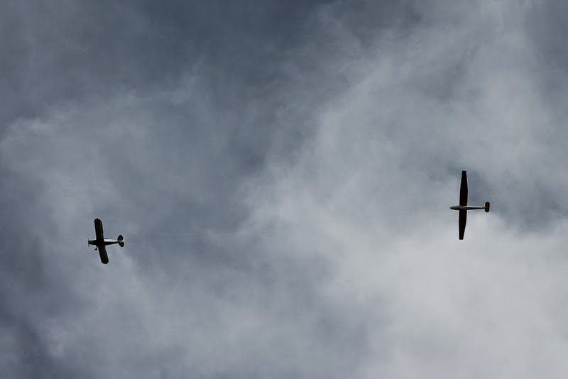
Our first stop was the Mountain Valley RV park in Tehachapi that our friend Marty had recommended.  The park is right on the runway of a small airport that is primarily used for sailplanes.  It was actually very quiet as there were only a few take-offs and landings a day.  This old crop duster was used to pull the glider into the air. 
This must have been a lesson because they were not going very high before the glider released the cable and landed.  They then hooked up again and were pulled into the air.  When I took a few flight lessons years ago we called these touch and goes.  The difference here was the glider would touch and then have to hook up to the plane to go.
One flight was so short that the plane and glider landed at the same time.  As you can see, wind energy is a big deal in a lot of places out here.
The reason for the celebration?  There was actually green grass growing here.  We were out of the desert at least for a couple of days.
Having grown up by the tracks I have always been a bit of a railroad buff.  As kids, my friends and I played on all the old rail cars parked in the local rail yard.  The first gift I remember was a Lionel train when I was six.  Only later did I realize that the train was as much a toy for my dad as for me.   We came to Tehachapi, an old railroad town, to see the Tehachapi Loop.  The town celebrates its railroad heritage with a park displaying old signal poles and a museum (that was closed).
They even have an old water tank from the days when the steam engines needed to fill the tanks with water to produce the steam for locomotion. 
The loop was needed to reduce the grade over the mountains between Bakersfield and Mojave for the Union Pacific.  It is now the mainline for the Burlington Northern Santa Fe, BNSF, railroad.  It was constructed in the 1870's by 3000 Chinese workers who also blasted several tunnels to get the tracks over and through the mountains.  Even though there are up to as many as 40 trains a day using the loop, we took our lunch with plans to stay as long as needed in order to see a train come through.  We were told that sometimes you have to wait quite a while to see a train.  We were rewarded with not one, but three trains within two hours.  We lucked out because the trains were held up earlier for track maintenance.  We talked to another couple who told us they had come earlier that morning and waited a long while and no trains came through.   Here an eastbound (up hill) train enters the loop through tunnel number nine.  You can click on the pictures to enlarge them.
Here the three engines pulling this 107 car train are in the .73 mile loop and the two engines that are pushing can be seen on the right.  So you can see the first and last engines of a train that is nearly a mile long.
Here the three engines are passing over the cars that are 77 feet below coming out of the tunnel.  The loop allows the grade to remain a steady 2%.
Nanc was trying to get the engineer to blow his horn.
After leaving the loop the train continues to snake its way up the mountain.  Even these kinds of weaving turns are unusual for railroads.  The first engine is about to go around the turn and out of sight.......
......while the pushers have still not passed over the tunnel in the loop.  I did not time it, but I'm sure it took more than half an hour for this long train to climb through the loop.
Not long after the up hill train passed we heard a whistle and a downhill train came around the corner.  This was another very long train, but all the cars appeared to be empty.
After watching this train through the loop we heard another one coming downhill so we moved to the tunnel where it would exit the loop.  This train was not very long so we did not get to see any cars above the tunnel as the engine exited.
We moved a bit farther down the track in time to see the second downhill train passing the empty first one that was parked on a siding.  These sidings were used for trains in each direction to pass and in the old days to add water to the locomotives.
Here is an aerial view of the loop I found.  We were standing on the right about half way up to view the whole loop.  Even if you are not a railroad buff the Tehachapi loop is a worthwhile stop.  Here is a link to a site with information about the best places to view the trains.  It really was very cool!