Wednesday, June 27, 2012

Fort Peck Dam

If you ask any of my former students they will tell you that I loved to use maps when I taught.  Sometimes, when using them, my mind seemed to wander and I can now reveal that when that happened it was because I was looking at the map and wondering what that place was like.  One of those places was Fort Peck Lake in Montana. How was it possible that there is a huge, 140 mile long body of water, in the low rolling hills of Eastern Montana.  So Fort Peck was always on our list of places to visit and it did not disappoint.  The dam and its construction is a true story of American can do.  In 1933 at the height of the Great Drepression there were people working on this project within 10 days of President Roosevelt signing the law.  At one point there were over 10,000 people working here and over 40,000 living in a place where there had not even been a town before it started.  I guess the government could create jobs back then, but too many people seem to think that is not possible today. 
 Fort Peck Dam, which was built to control floods, was constructed as a hydraulic earth fill dam and is still the world's largest built with this technique.  It was built using 126,000,000 cubic yards of mud from the river bottom that was dredged and pumped to the site through miles of slurry pipe.  This watery sludge was compacted and the water squeezed out by the weight of the next layer.  It is almost four miles in length, 250 feet high, 2/3 of a mile wide at the base and 50 feet wide at the top.  The project was not completed without major problems.  On September 22, 1938 two weeks after the major work was done a quarter mile of the dam collapsed causing a two year delay.  This disaster seemed to be the result of the rush to get the job done.  The dam has been blocking the Missouri River for over 70 years so it appears to be working just fine.     
 To accomodate the huge influx of people, a whole new town, Fort Peck was built.  Much of it remains today including the theatre where they have plays on summer weekends.  There were also 18 boomtowns that sprung up to support the growing population.
 The spillway (which keeps water from going over the top of the dam) is three miles from the dam.  It has sixteen 75 ton gates that can be opened to lower the water in the lake. They have been used only five times, most recently in 2011 when the water nearly went over the top before the gates were opened.  The spillway was pictured on the first cover of Life magazine and because of its size was misidentified as the dam.  
This is looking from the bottom of the spillway.  The concrete section is a mile long.  When it is used, the spillway puts the water into the Missouri seven miles below the dam.
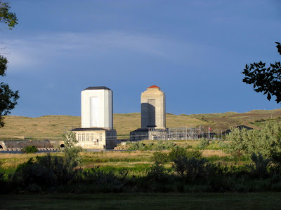
 The first hydroelectric powerhouse was added in 1941 and the second in 1958.  The towers hold open top surge tanks with water that is at the same level as the lake.  The tour of the powerhouse was one of the best we have ever been on.  First of all we were the only two on the tour so it was really personal.  We were encouraged to lean against the side of the turbine generators so we could feel how much less the vibration is in the newer one.  We were even allowed to touch the turning shaft that connected the water turbines to the generators.  Much different than our tours of  Hoover and Glen Canyon Dams.  No pictures were allowed.  
 Left are two of the four outlet tunnels that carry all the water of the Missouri under the dam.  The other two tunnels go into the powerhouses.  All of the tunnels are more than a mile long and almost 25 feet in diameter.  Each tunnel is designed to carry double the normal flow of the river.
 The Interpretive Center not only has excellent exhibits on the dam's construction, but also a great display of fossils that were discovered during construction.
 Two of the dinosaurs from the area.  Fossils are still being discovered today.
Of course when you are on the Missouri in Montana you are where Lewis and Clark travelled on the Corps of Discovery.
 Storm clouds above the plains below the dam where the Milk River flows into the Missouri.  Lewis and Clark described this confluence in their journals.
 It was the first day of summer during our visit, but spring was the season here for the many flowers in bloom and many birds chirping. 
We did not visit Fort Peck on our 1982 bike trek so we took advantage of a beautiful day to bike across the dam and enjoy the views of the lake and surrounding land.  There are few places where you can get to the 1500 mile shoreline without a boat. 
I know this post has a lot of big numbers, but Fort Peck is a big, big place.
Saturday, June 23, 2012

Heading East, Friends - Old and New

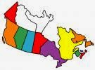
We left Jasper and started our slow trek back to WashPA.  As we drove out of the mountains the land quickly changed to the high plains of Alberta.  We continued to see wildlife coming upon a big black bear and a huge mule dear buck with a big velvet rack right along the road.  Our plan is to go to Montana and head east through North Dakota along the same road we cycled on our 1982 transcontinental trip.  We have crossed parts of that trip's route before, near the start in Washington and at the end in New Hampshire and Maine, but we have never driven many miles of it in the rig.  It will be interesting to see what we remember, what has changed and what hasn't, along that road.   We continued our - "we do not have to go to Alaska to experience this" - when, as we went through a tar and chip zone, a truck kicked up a stone and we added a chip to the windshield to the list. 
We decided to spend a couple of days near Edmonton and I got malled.  We went to West Edmonton Mall which was the the world's largest when it was built.  In addition to over 800 stores and a casino, there are also those things pictured above; a sea lion, an amusement park, a pirate ship and a wave pool. We only walked around and had a snack at one of the many restaurants, but even I, the ultimate non shopper, had to admit the place is impressive.  A note to anyone heading north, we paid less for diesel here than we did in Montana on our last fill up.  Alberta has a booming oil economy.
 We did make some new friends as soon as we pulled into the RV park when our new neighbors, Ron and Louise, invited us over for a drink.  They are from Vancouver Island and we had a great couple of days learning all about that beautiful place we have on our to do list to visit.
 A roadside curiosity along the road in Medicine Hat, Alberta is the world's tallest tipi. 
We wanted to add Saskatchewan to our provinces visited and spent at least one night in during our five years on the road.  So on our way to Montana we headed off the Trans Canadian Highway and  we encountered another "we did not have to go to Alaska moment" when we came upon this well marked frost heave.
 We stayed in Val Marie, a small town close enough to the US border that it was part of it from the time of the Louisiana Purchase until the present border was agreed to in the 1880's.  Grain elevators are a real part of the landscape all across the Great Plains in both the US and Canada. 
 We picked Val Marie as a stop because it is the home of Canada's Grasslands National Park.  This park is different from the Tallgrass Prairie National Preserve in Kansas because this land is the largest piece in Canada that has never been plowed, so it is in its natural state.  The plains do have a different look than the soaring mountains, but with the big sky they have their own unique beauty. 
 Buffalo have recently been reintroduced into the park and join the many prairie dogs and huge variety of birds.  You have to be a more careful observer to see the wildlife in the plains. 
The next day we crossed the border at a place so small that we were the only vehicle there.  The American border agent came aboard and open a few doors while we sat and chatted with his Canadian counterpart who shares the same building.  This is the first time we crossed at a spot where both countries shared one building.
 We were staying in Fort Peck and knew our WashPA friends, whom we have not seen since last summer, were passing through nearby Glasgow on the train on their way to a trip through many Western national parks.  Our first thought was to get on the train and travel with them for one stop and then catch the Eastbound train an hour later.  That plan did not work out because their train was delayed four hours while tracks that had been washed out by a flood were being repaired.  
Our visit was only about one minute while a few passengers got off and on the train in Glasgow.  It was a short visit but it is always great seeing old friends.  Here is Nanc, Jim, John, Patrice, Ron and Becky.  We even had Mardi Gras beads for them.  We hope John shared:-)

I have added a new feature to the blog, My Blog List.  Most of them are RV blogs, with the exception of killing Mother.  All but the bottom three will move to the top of the list when there is a new entry.  Marty's Travels is an exception as, for some reason, it does not update, but it is still current.  Hitchitch is a site with many RV blogs. See Ya' Down the Road is no longer active but I found it to be one of the best when we were planning to go fulltiming and the material is still very useful.

Tuesday, June 19, 2012

On to Jasper and the Beautiful Mountian Vistas Continue

We left Banff and drove the 296km to Jasper National Park on the Icefields Parkway with beautiful mountains soaring above us on both sides of the road. The weather continued to be less than wonderful but we were not totally shut out as we had been on the drive to Banff.
Our crossing Bow Summit, the highest point on the parkway (2,088m), was very timely as snow that had fallen minutes ago was off the road and the clouds lifted to offer this spectacular view. We did not stop because the pull off was snow covered
  Our luck continued to hold with no snow or rain, just clouds, north of the pass. The clouds were high enough for us to have this great view. Imagine what it would have looked like with a bit of blue sky.
The Saskatchewan River meanders along the road for miles, flowing with snow melt and ALL that recent rain. The river valley bottoms are covered with rocks that have been carried from the mountains.
What a view looking down on the parkway from the next pass.  Because of the lower elevation it had not snowed at all. You can really see the round bottomed glacial valleys. Center right is the Weeping Wall, a stretch of a couple of kilometers with waterfalls and much water coming down the stone wall.
  The parade of animals goes on. Bottom left are a mother and young Big Horn Sheep and right is a male. Top is a Mountain Goat we watched scurry across what looked to us like a shear cliff. We saw several of both species. The back drop for this Mountain Goat was much more dramatic than the herd we saw in a parking lot last fall in Montana.
  We did not get up close with this elk, she got up close with us right outside the rig. This beautiful Spruce Grouse was scurrying through the woods.
  Our we did not miss this experience by not going to Alaska tour continued when we saw all these bears. We have discovered that you really don't have to travel very far off the beaten path to have these kinds of encounters. We took a short drive on a secondary road and saw the Grizzly and Black Bear (left) right along the highway. I loved the picture with the dandelions in her mouth.
  This is the mother who was eating the dandelions with her two year old cubs. We watched them until a couple of people walked to within about twenty feet of them and the bears moved farther into the woods. The rangers came along and warned the idiots how dangerous it was so I did not get a video of an attack that I could have sold to some reality TV show.
Another thing we had hoped to see in Alaska was glaciers. We got to do that here also. As you can see the clouds moved on (for a day) and we had a beautiful, sunny day to visit the Columbia Icefields. This is the largest area of ice outside the Arctic. This picture was taken from the terminal moraine, the spot of the glacier's furthest advance. All the rocks across the road are moraines left behind as the glacier melts. The lateral moraines on the side gives you an idea of how thick the ice is
To get out on to the glacier you have to take a Snocoach, a modern vehicle built in Calgary specifically for this job. They have one of these in Antarctica for the scientists and over twenty here. They sure are a big improvement over the old bus they mounted on treads for the original tour machines. You can take a guided hiking tour onto the glacier, but you are not allowed to venture on to the ice alone because of the danger of falling into the crevasses.
Because they get more than seven meters of snow each year, the road on to the glacier has to be remade each year. The trip starts down an 18% grade on the lateral moraine. By comparison the steepest road we have driven on was 10% and anything over 6% is always a thrill in the RV. The dark dots at the left on the glacier are the snocoaches.
Looking across the Athabasca Glacier at the ice at the top that is part of the Columbia Icefield. The icefield which covers 325 square kilometers is the largest in the Rockies. The glacier moves down the mountain while a cap stays in place. This location is unique because it is on three continental divides, with the melting water flowing into the Arctic, Atlantic and Pacific Oceans. This is the only place in the world that this occurs.
Here we are on the Athabasca Glacier. The ice at this point is thicker than the Eiffel Tower is tall, over 350 meters. It was a really neat experience.
The marker indicates where the glacier's toe was in 2000. Several kilometers of it have disappeared in the last century. For all those global warming skeptics, it should be here for you to see in your lifetime, but it might be a good idea to get the grandchildren here because it will probably be gone during theirs.
The views here are some of the most spectacular we have seen in our travels. We have been to the Tetons, Yosemite, Zion, Gros-Morne and many other national parks. They are all beautiful but they cannot match Banff, Jasper and the Icefields Parkway when it comes to the total volume of beauty. For almost the entire 300 km you are surrounded by soaring snow capped peaks, rivers and waterfalls.
Just a couple of the many waterfalls. Left is Tangle Falls and right the Athabasca Falls. The background is the marks in the rock from the glaciers moving across them. Some were as smooth as a sidewalk.
This mountain was overlooking the campground at Jasper. This picture was taken at 10PM. It stayed light very late. It took us a while to realize that we have never been this far north. We are even closer to the North Pole than we were in the Northern most tip of Newfoundland. Not Alaska, but really far north.
While we are not in Alaska we continue to enjoy Mark and Renita's adventure. We had a Betty's RV Park sign we promised to put up at the sign forest in Watson Lake, Yukon and Mark made sure it got there this year.  Many thanks and Betty thanks you too.
To River Cat, the header photo on the blog is at the Elks Lodge in the Keys. I thought of changing it but I love it and we will be heading back there in January.

Friday, June 15, 2012

Beautiful Banff

Once in Canada we headed to the Canadian Rockies and Banff National Park. As if a sure sign of things to come, it rained and we were driving in the low clouds for much of the trip. Our attitudes improved somewhat when, before we even arrived at our site in the campground, we saw a couple of coyotes and a herd of elk. This also was a sign of things to come as we saw many, many animals. There was so much rain that there was flooding throughout Alberta and it snowed in the mountains most nights. Our last day in Banff we experienced the worst weather we have had in five years on the road, it SNOWED several millimeters and went down to 4 degrees:( During our five days in Banff the weather was nice only one whole day and one morning and these couple of good days did make for a worthwhile experience.
The one sunny day sure shows why so many people come to Banff. What a fantastic view of the mountains looking down Banff Avenue.
The wildlife was everywhere and any time we ventured out we saw wild animals. Top corners are (left) an elk bull and (right) a mule deer buck with their antlers still in velvet. Middle is a Clark Nuthatch. Bottom is a coyote and couple of ground squirrels and part of a herd of elk cows and their young. One rainy morning the elk tried to bed down right across from our rig, but a coyote would give them no peace and ran them off. Seeing animals in the wild is always a neat experience.
  This is typical of what the weather looked like, but it also is typical of how spectacular the scenery is when you can see the mountains in Banff. These four shots were taken standing in one spot in the campground and looking in four different directions. I really do hate to say it, but the snow really did add to the beauty of the mountains. I just wish there had been blue sky behind them.
This is the famous Banff Hot Springs Hotel which overlooks the Bow River Falls that where at more than twice their normal flow. The hotel is one of several that were built by the Canadian Pacific Railroad to entice people to travel. One of the rainy days we went and checked out the hotel and shops so we could see how the 1% lives.
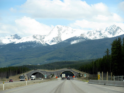
Maybe it is a good thing the weather was so bad on the drive in, as it was really hard to keep your mind on the road with beautiful mountain scenes everywhere you looked for well over 200 miles. A unique feature of this section of the Trans Canadian Highway is these overpasses that are built so wildlife can safely cross the road. They are used by several species of large mammals, including deer, elk and bears.
  We took advantage of that one nice day and drove to Lake Louise, one of the most famous and beautiful glacial lakes in the park. The color of the water and the soaring mountains topped with glaciers makes for a wonderful view. There were also a few natives - Canadian Geese.
We hiked along the lake and enjoyed the beautiful scene. Blue sky sure improved the view and the attitude.
The color of the water is like nothing we have seen before. It is caused by the silt from the melting glaciers, which they call glacial flour because it is ground so fine.
Lake Louise, with the famous hotel and ski slopes in the background. You can see the brown silty water coming into the lake and the beautiful blue-green water as the mud settles. 
Here I am standing on a huge chunk of ice that had recently fallen from the ice falls on the right. We  crossed several avalanche runs on our hike beyond the lake. Somewhat dangerous, but rewarding.
What fabulous mountains. The rounded bottoms of the valleys are from the glaciers and the piles of rocks are the moraines they leave behind. The mountain is still capped with a glacier.
We did not opt for the canoe trip, but it sure looked like it would be fun to get out on the water – on a warmer day.
We will take a table for two with a view. We did not, but the view lived up to all our expectations.
  Moraine Lake is near Lake Louise, but higher so it still had a lot of ice on it. The area is know as the Valley of Ten Peaks and was once pictured on the 20 dollar bill.
  Just one more wonderful view. Did I mention how sunny skies make all the difference in the world?
This is what we awoke to on our last day in Banff. Not what we had in mind when we started this follow the sun lifestyle. Bad roads, snow, wild animals and beautiful mountains, all things we have experienced this “summer” without going to Alaska.