

 Overlooking Horseshoe Bend where we rafted.
 Sunrise on the Vermilion Cliffs
 Replica of Powell's Boat
 Lake Powell; The white shows the 100 feet the lake is down.
 Glen Canyon Dam
 On the Colorado
 Mike, Our Great Tour Guide
 The slanting wall of the canyon is sand that has blown in from the desert above.
 Entrance to Antelope Slot Canyon
 Inside the canyon
 Canyon Walls
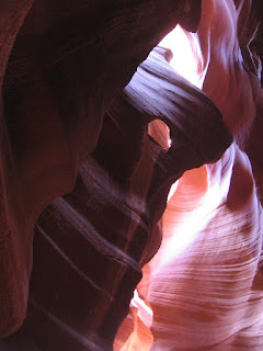 Sun and Stone
We are at the Page Lake Powell Campground in Page, Arizona just north of the Grand Canyon. Page is the newest town in the USA being founded in 1957 as a construction site for the building of the Glen Canyon Dam. The first morning we got up at 5 AM to watch the sunrise on Horseshoe Bend and the Vermilion Cliffs. It was great because there were no fences and you could go right to the edge. We then went on a tour of the 587 foot high dam that turns the river into Lake Powell, a 190 mile long reservoir with a shoreline longer then the west coast that stores water for the Southwest and produces electricity. The lake is down over 100 feet from its high mark because of an eight year drought, though they expect the Rocky Mountain snow melt to add fifty feet of water this spring. The lake is named for John Wesley Powell, a one armed Civil War veteran, who lead the first expedition down the Colorado River in 1869. We went to the Powell Museum which had exhibits on his journey as well as other early trips down the river. Yesterday we took a raft trip from the dam 16 miles downstream to Lees Ferry. To get to the river at the dam you must take a bus through a two mile 8% grade tunnel that was originally built to get construction equipment to the river. Because of homeland security, before the bus entered the tunnel everyone had to get off and place their bags in a cart which then preceded us to the bottom. What a joke! Before we got off the bus we had to put on hard hats because people have thrown coins off the bridge overhead. The trip was wonderful seeing the dam, Horseshoe Bend, the river and other things we had seen from the rim. On a stop along the river we saw petroglyphs that were from 200 to 2000 years old. On the bus trip back to Page as we crossed the Navajo Bridge we saw a California Condor souring over the river. At one point they were so endangered there were only a total of 22 condors in the wild. Over 200 have now been reintroduced here, in California and Utah. They are amazing birds and can have a wing span up to ten feet. Today we toured Antelope Slot Canyon on the Navajo Reservation. At each end of the canyon is a wide wash that often floods during the summer monsoon season. The slot canyon was carved where the water forces its way through the hill. The water that may be four feet deep in the wash rises to twenty feet in the narrow canyon and has created beautiful shapes in the sandstone. With the Sun shining in from the top the colors are amazing.


.JPG)


.JPG)
.JPG)
.JPG)
.JPG)


 Chihuahuan Desert Vegetation

.JPG)
.JPG)
.JPG)
.JPG)
.JPG)


