Monday, June 29, 2009

The Oregon Coast is "COOL"

Bridges of the Oregon Coast
Lincoln City Kite Festival
The world's smallest harbor and the world's shortest river.
Spouting Horns
Heceta Head and Yaquina Head Lighthouse with Fresnel lens background.
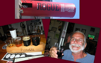
A rogue with a Rogue.
Sea Lion Cave and Rookery.

We continue our drive up the Oregon coast and, as if they want you to have a real time Oregon experience, it began to rain as we passed Cape Foulweather. We are at the Chinook Bend RV Resort near Lincoln City, a campground on the bank of the Siletz River, a tidal river where the water flows "upstream" when the tide is coming in and then reverses as the tide goes out. As the title states, the Oregon coast is a cool place with temps being in the sixties with a lot of wind. This has been okay on the days when the sun is out, which has been most, but it can be bone chilling when it is overcast. It is strange to walk on the beach and see people bundled up in winter coats. I don't even have to wear my glasses because there are no cute little bikinis to see. The other half of cool is the neat and different things we continue to see and do as we travel the coastal highway. Even the bridges over the many streams and rivers flowing to the Pacific are unique. Most of them were designed by Conde B. McCollough in the 1930's and each one is different, unlike the cookie cutter bridges on today's interstate roads.

In Lincoln City they take advantage of the ideal winds and have a kite festival that is similar to the one we went to on South Padre Island in February. There were huge kites anchored in the sand and several choreographed performances with individual and team kiting. One group, iQuad, was at the Texas festival. We have included a short video of one of their routines. Lincoin City is also the home to one of several local attractions that are described by a superlative. Here, it is the "D" River which holds the Guinness Book record for being the shortest river in the world. It is only 120 feet from fresh water Devils Lake to the Pacific Ocean. Kayaking the entire length of the river is a cool thing to do.

In nearby Depoe Bay we saw the Pacific with some of the largest waves we have ever seen. The area is known for its spouting horns that channel the waves into holes that blow the spray and mist high into the air. We were there at high tide on a day with strong winds coming off the water and it was quite a show with the water coming over the high seawall. One local told us that during winter storms the spray blows across the highway. This is one of the best places to get an up close look at the waves crashing onto the rocky shore, but many other spots allow for interesting but less specular waves. It is so cool watching the waves crashing on to the rocky shoreline. Also located here is the world's smallest navigable harbor.

We visited two nearby lighthouses and both offered tours. The Yaquina Head Lighthouse is the tallest in Oregon at 93 feet and stands 217 feet above the ocean. The area around the lighthouse is administered by the Bureau of Land Management and has several hiking trails and wildlife viewpoints. There is an excellent Interpretive Center with many exhibits on the lighthouse including a full-scale replica of the lantern. The Heceta Head Lighthouse tower is 54 feet high and stands 205 feet above the water. It is the only one we have ever visited where you get to see the gears working as they rotate the lens. Both of these lights can be seen over twenty miles out to sea with their first order Fresnel lenses that have elaborate prisms designed to focus and project the oil lamp flame used when they were built in the 1800's. The lighthouse keeper's house at Heceta Head has been turned into a bed and breakfast and I'm sure the rooms would have cool views.

Newport is the biggest city in the area with many attractions including an aquarium that we did not visit. We did enjoy the historic Bayfront with its mix of working fish processing plants, shops, bars and restaurants. A big attraction for me was the Rogue Brewery which brews some of my favorite beverages. We were there as workers were finishing their shift and many of them came into the bar to enjoy some of their own handiwork. WOW what a cool job!!!

The last of the superlative attractions in the area is Sea Lion Caves which is advertised as the largest sea cave in the world. What they don't tell, but what you quickly discover when you step into the elevator to descend 200 feet, is that it is also (in our opinion) the smelliest attraction you will ever visit. The aroma of years of sea lion sh_t assault your nose the entire time you are underground. That said it was cool to be in a sea cave with the waves coming in and seeing the sea lions. Outside you can also look down on the only mainland rookery on the coast.
1Quad Video
Tuesday, June 23, 2009

Coasting Along The Coast

Check out the size of those mussels.
Whale!!!!
The gardener's cottage and the pond.
A rose is a rose.
Oregon coastal scenes.
Bald Eagle, gulls, sea lions and seals, Oh My!
Oregon Dunes
A buoy boy Nanc met along the trail and Jim acting like Lawrence of Oregon.
Cape Arago and Umpqua Lighthouses.
Chainsaw carvings

We are at the Charleston Marina RV Park on Coos Bay in Charleston, OR. The drive here on the Pacific Coast Scenic Byway was along the ocean to Port Orford and then turned inland and traveled through forest and farmland. Near the town of Bandon we saw many cranberries bogs. This was a first for us, although their harvest is late in the year. The Charleston marina is popular with both commercial and sport fishermen and there is a large seafood processing plant. Many people are crabbing and others are out along Coos Bay digging clams at low tide. One day while walking I met a woman who was cleaning the largest mussel I have ever seen. She gave me three and told me how to cook them and Nanc and I enjoyed these wonderful morsels as an appetizer.

Within five miles of the marina are three Oregon state parks and one county park along the coast. Sunset Bay has a beautiful sheltered cove where a few hearty souls were in the water. There is also a viewpoint to see the 44-foot high Camp Arago Lighthouse which, interestingly, is not located on Cape Arago and is also not accessible because it is located on a private road. Next is Shore Acres, a botanical garden that was first planted by lumber baron Louis Simpson who built a mansion here overlooking the ocean. His gardens featured exotic plants from all over the world and the grounds also included a Japanese garden and pond which still exists today. The gardens feature various flowers at different times of the year and the roses are particularly spectacular in June. The original home burned and the newer one, which was built with wood salvaged from a shipwreck, was in such disrepair that the state tore it down after purchasing it in 1942 when the property became a park. An observation building now stands where the mansion once stood. The only original building that still exists is the gardener's cottage which, on the day we visited, was being used for a wedding. Next along the road are Simpson Reef and Shell Island, both of which were covered with dozens of seals and sea lions. It was not only a sight, but quite a sound experience as well, with the barking of the sea lions making themselves know well before we even laid eyes on them. They are such funny animals and we enjoyed their antics as we stood and watched. At the end of the road is Cape Arago that overlooks the offshore rocks of the Oregon National Wildlife Refuge. As if right on cue, proving the guide book's statement that this is a good place for whale watching, two rather large whales were feeding near the cape. We sat and watched in awe until they both swam out to sea.
North of Coos Bay the coastline changes dramatically as you enter the Oregon Dunes National Recreation Area which creates over 45 miles of sandy beaches and dunes as high as 500 feet. The dunes have changed since people have planted European beach grass to stabilize and slow their movement. There are now higher dunes near the beach as the sand piled up behind the planted areas. This has created a sheltered area were huge mats of vegetation have grown and forest areas with tall trees growing through the sand. We hiked the six mile John Dellenback Dunes Trail that starts in the forest then enters the high dune area, where you feel like you are in the Sahara, then into the hummocks and finally over the fore dunes on to the deserted beach. On our return, the wind was blowing hard enough that you could actually see the sand moving and the shape of the dunes changing before your eyes. We also saw an eagle soaring over the dunes from one island of trees to another. This is a great hike which gives you an up close look at all the different parts of this unique environment. There are designated areas on the dunes that are popular with ATV riders and on the weekend there were hundreds of machines zooming all over the place. It looked like a lot of fun and something we will have to try on a future visit.

Near Winchester Bay is the Umpqua Lighthouse which overlooks the Umpqua River as it flows into the Pacific. This lighthouse is unique because the light beam shines in both red and white. We did not get to see this, another reason we will have to return in the future and spend the night.

We had another experience unique to the woods when we went to Reedsport to see a chainsaw carving competition. We only got to see one carver at work but we did see all the finished pieces. It is amazing what these artists can do with a saw.

Lastly, if it is Tuesday it must be time for Allan and Sharon to arrive. They pulled into Charleston in the afternoon and we went to dinner at the Blue Heron Bistro, a German restaurant in Coos Bay. We always have a great time chatting and spending time with them. Our scheduled stops are changing though and we will not be seeing them again until we return from Vancouver in August where we hope to hook up again in Washington.

Tuesday, June 16, 2009

Trees, Seas & Lighthouses

Beachfront RV Park
Tsunami warning sign and a mark over Nanc's head showing the height of the 1964 Crescent City tsunami.
Nanc hiking down to Whaleshead Beach.
The Oregon Coast
Humbug Mountain, the highest point on the coast.
Port Orford in the foreground and Cape Blanco above from atop Humbug Mountain.
Wildflowers
Cape Blanco & Battery Point Lighthouses
Paul, Babe and the Sky Trail gondola among the tall trees.

We are now at the Beachfront RV Park in the Port of Brookings, Oregon overlooking the Pacific Ocean. It is great to sit in the motorhome and be able to see boats coming and going and watch the waves breaking on the beach. A new thing we have encountered traveling the coast is tsunami warning zones in all areas near the coast. Crescent City in Northern California was heavily damaged in 1964 by a big wave from an Alaskan earthquake. We sure do hope we don't hear that siren. I did buy a fishing license but they are dredging the harbor channel and dumping it right off the beach, turning the water into a muddy mess. Hopefully, the fishing will get better as we travel up the coast. Last Friday we had a great time watching the Penguins defeat the Red Wings in the Stanley Cup final. With this and the Steelers' Super Bowl win Pittsburgh is once again the "City of Champions."

We plan to take the next month to enjoy the coast while slowly traveling the Pacific Coast Scenic Byway. Oregon offers wonderful access to the ocean which includes many state parks and a law guaranteeing the public the right to use all beaches. There is a beautiful vista at every turn with rocks thrusting out of the water, crashing waves, isolated beaches, streams flowing into the ocean and tree covered mountains. It is so different from any other seashore we have visited and, as usual, pictures do not do it justice. The weather has been cool with at least part of every day being overcast with low clouds and fog on the hilltops. It has been ideal for hiking so we took advantage of two great hikes. One started at House Rock Viewpoint and traveled down through the forest and meadow and then along the ocean to Whaleshead Beach. Another was a hike through old growth forest up to the highest point on the Oregon coast Humbug Mountain. This hike had only occasional glimpses of the water but at several points we could see Cape Blanco, the westernmost point of Oregon. There were many beautiful flowers along the trail and we saw a Bald Eagle soaring above the trees. Both of these hikes allow for wonderful views and are highly recommended.

We visited the sites of two more lighthouses. The Battery Point Lighthouse in Crescent City is a Cape Cod design with the keepers house built as part of the lighthouse. The access to this lighthouse is under water at high tide. We also went to the Cape Blanco Lighthouse but could not get an up close look because it was closed the day we were there. We are looking forward to seeing many more as we travel north.

The day we went to Crescent City we drove to Klamath, California to the Trees of Mystery and Sky Trail. At this tourist attraction you are greeted by a huge Paul Bunyan and his blue ox, Babe. The trail winds through the woods with a number of narrated stops about the Sitka Spruce, Douglas Fir and Coastal Redwood trees. The Trail of Tall Tales uses redwood carvings done with a chainsaw to tell the folklore of Paul and his lumberjack friends. The high point (literally) here is the Sky Trail, a gondola ride to Ted's Ridge. It was neat traveling through the tops of the big trees. The observation deck at the top offers a view of the Pacific on one side and the back country forest on the other where we could see a couple osprey nests with one holding baby chicks. The End of the Trail Museum has a large collection of Native American artifacts from several tribes. Clothing, pottery, baskets and weapons are some of the items on display.

Allan and Sharon Frey, who we met in Rockport and visited with in Apache Junction, are traveling the same route along the coast. As it turns out, our stays are overlapping in a few places along the way. On our last day here, they pulled in and we spent the afternoon visiting and having dinner. We have the same plan for next week in Charleston. It is always great to see friends on the road to catch up on travels and find out what interesting things they have experienced.

Friday, June 12, 2009

Giants and the Lost Coast

Driving the motorhome on the Redwood Highway.
Nanc & Jim size up this BIG log.
The roots of the fallen Dyerville Giant.
Looking up at the 345 foot Founders Tree.
The tallest tree is the Grandfather Tree which is "only" 245 feet tall.
Inside the One Log House.
The Shrine Drive Thru Tree.
Seals at Shelter Cove.
Dead starfish on Black Beach.
Black Beach with the mountains meeting the Pacific under low clouds.
Cape Mendocino Lighthouse

We spent three days at Richardson Grove Campground near Garberville, California where we traveled to the Avenue of the Giants and the Lost Coast. The avenue is the original Redwood Highway right through these massive trees where many are so close to the road they have damage where vehicles have hit them. While it is impossible to put the redwoods size into perspective, a 250 foot tree is looked down upon by many that soar to over 350 feet and up to the record of 380. Trees 200 feet higher then Niagara Falls are common. Another way to try to understand the size of these trees is when the first narrow gauge railroads where used to move the trees, each train could only carry one tree. The oldest of these worlds tallest trees are over 2000 years ago. They are so tall they pass through three climate zones so the needles at the top are different from the ones at the bottom. It is hard to imagine that the redwood seeds are smaller than a grain of rice but new trees can also sprout from the fallen trees and burls. The trees are so massive that there is more biomass here per acre than in the Amazon rain forest. We stopped at a few of the local attractions like the Grandfather Tree, the One Log House and of course a drive through tree. We enjoyed walking in the groves among both standing and fallen giants. The 360 foot Dyerville Giant which fell in 1991 gives you an up close look at the length of the trees. The roots of these giants are very shallow so when one tree falls others nearby often follow. This creates open space for young trees to receive sunlight and grow and opens the forest floor to other vegetation. We were in awe as we walked and drove among these giants and thankful that these few groves, that have been preserved by several state and national redwoods parks, which is less than 10% of the old growth trees, have been saved for future generations to behold and enjoy.

I really have a thing about looking at the map and finding roads that just end and than driving them to see what is there. The drive to Shelter Cove on the Lost Coast is such a drive. (Though there is a forty mile dirt road you can take to drive out.) When the Pacific Coast Highway was built the engineers decided at this portion of the coast it was not possible to construct a road. After travelling it we have to agree. The last twenty miles to the coast did not have a single stretch of straight road and the last three miles was a down hill that "dropped" over 2000 feet. Surprisingly, there is an RV park and we talked to the camp host who had driven his 36 foot motorhome over that road. He said they do occasionally get a 40 footer but there is no way we would ever take our home there. Shelter Cove is a development of vacation and retirement homes with a couple motels complete with a golf course and air strip (there was not a single plane on the ground) that seems like it never met its potential. The whole place was shrouded in fog and low clouds hugging the tops of the forested hills which we drove through as we made our decent. We did take a long stroll on the beautiful black sand beach that had warning signs about how dangerous it was to swim. Winter storms here wash out so much sand that huge rocks on the beach that are now twenty feet high grow to 40 feet above the beach. There were seals feeding in the surf and lounging on the off shore rocks. One spot on the beach was littered with mussel shells and many dead starfish. The high hills came right down to the beach and the part of the Pacific Coast Hiking Trail which goes along the beach here has signs warning that many areas are not passable at high tide. In the sheltered cove there was a boat launch ramp but there were only a couple of boats out in the ocean. The Cape Mendocino lighthouse was moved in 1999 to Shelter Cove from its original location at California's Western most point. This lighthouse is only 43 feet tall but was sitting on the hillside 422 feet above the ocean making it one of the highest in the US. It was in disrepair and in danger of falling into the water when it was moved to its new home. This drive to the edge of the continent is well worth the effort and we felt we got a glimpse of an area that not many have experienced.

Tuesday, June 9, 2009

Sonoma County

Coastal Wildflowers
We had to walk through the woods to get to this little isolated beach.
The Russian River flowing into the Pacific Ocean. The seal nursery is at the point.
I like this one!!!
Sonoma
Mission San Francisco Solano
Peanut's Characters

We planned to spend four days at the Sonoma County Fairgrounds RV Park in Santa Rosa then extended our stay by a couple of days since there was so much to do in the area. There are many wineries which made Nanc happy and several micro breweries which pleased Jim. We went out to dinner every night, often to breweries, something we don't do nearly as often as we did when we were in our stix and brix. One day we drove the Russian River Valley through neat little tourist towns, redwood forest and farmland to the Pacific Ocean at Jenner. We drove a little of the coastal highway and strolled on the beach. The coast is absolutely beautiful here with many small beaches, rock outcroppings and vistas. At the mouth of the river a large group of harbor seals where nursing there young on the beach. That same day we drove to Bodega Bay to look for a restaurant where we had eaten in 1993. We found Lucas Wharf and the calamari was as fantastic as we remembered.

We went to Healdsburg where several wineries have tasting rooms around the town plaza. This lets you try a bigger variety without having to drive, which is good thing. Nanc indulged herself by purchasing some “better” wines than she usually drinks. There was also a brew pub where we had dinner and I could try a couple of different craft brews.

Sonoma, another nearby town, is an older village where the last of the California Spanish missions was built in 1823. The Mission San Francisco Solano is the only mission constructed after Mexico gained its independence. There are, as expected, several wine tasting rooms, galleries and shops around the central plaza, but they are a little behind the times since no one has opened a microbrewery. Although, there was one tasting room which offered tastings of both local wines and craft beers but we decided one day of tasting was enough and that we would have to save this for another time. There was also an arts and crafts show in progress on the plaza which we enjoyed as we strolled around the town.

On three of the nights we were here we dined out so we could see the Penguins play in the Stanley Cup Finals. For two of the nights the results were very positive, but Saturday was terrible but we are not giving up. The good thing on Saturday was a restaurant we discovered in Sebastopol. GTO's, located on South Main Street, is run by Gene and Tess Ostopowicz who are originally from Pennsylvania. This little gem offers a taste of New Orleans in Sonoma County. We enjoyed a wonderful meal and talked about fulltiming which they said they would love to do at some point. If you are in the area and want a great meal make sure to check them out. You won't be disappointed.

Santa Rosa is a neat city with all the services you need and a nice downtown area with several restaurants and shops. It is the home of Charles Schultz the author of Peanuts. There is a museum, which we did not visit, and statues of the various characters around town. This is a place we could return to because it is well located for visiting everything from the vineyards, local farmers markets to the ocean. It could even be a good place for a day trip to San Fransisco.