The drive to St. John's, as with many road trips here, had a bit of everything with the thick fog being the worst. Getting to Avalon, the Eastern most area of Newfoundland, you must cross a section where the cold waters of Trinity Bay are only about ten miles from the warmer Placentia Bay so the fog was very bad for about 25 miles. At least traffic was light and we were on the TCH so the road was in good shape. The closer we got to the city the clearer it became. St. John's is the capital and about a third of all Newfoundlanders live in the area. We are spending a week at Pippy Park which is right in the city and a bit expensive, as are all urban campgrounds, but is well located for exploring the entire Avalon Peninsula.

The fog was as thick as Newfoundland pea soup.

We attended the tattoo at the Signal Hill National Historical Site. There was a unit of His Majesty's Royal Newfoundland Regiment, a artillery unit and a fife and drum band. They paraded and then had a mock battle to reenact the 1762 battle with the French that was the last of the Seven Years War. This was the last of four times that the French had captured St. John's in the 100 plus years of dispute over fishing rights. It was a grand show and very worthwhile.

Atop Signal Hill is Cabot Tower that was built to celebrated the 400th anniversary of his landing and Queen Victoria's Diamond Jubilee. The Hill was used by the military from the 18th century through WWII as a harbour defense. Signal Hill is the place were Guglielmo Marconi received the first trans-Atlantic wireless signal in 1901.

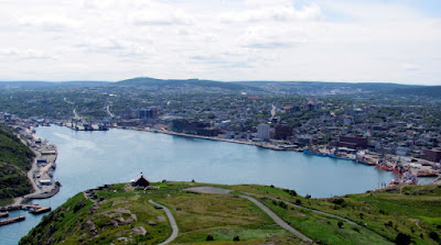
The city and harbour. The harbour is well protected from the Atlantic but is not very large. The downtown starts right on the water and climbs the hill giving great views as you walk. Because of the hills and water the city streets are very hard to follow. There is no grid and the names seem to change from block to block. For someone who grew up driving in Pittsburgh this is not a big deal but it can be confusing.

The Narrows is the entrance to the harbour. It is so narrow that during wars a chain was placed across it to prevent the enemies, French, American, German from sailing through it. There is a great system of trails on and around the hill (and the entire city). Parks Canada has a GPS you can use that not only directs you on the trails within the park but also gives you historical information at stops along the way.

Looking from the hill out into the Atlantic. In the foreground is Fort Amherst on the opposite side of the Narrows and in the background 11km away is Cape Spear, the Eastern most point of North America. You can see why the hill would be a good place to "signal" the city about approaching ships.

There are two lighthouses at Cape Spear. Left is the original 1836 light, the oldest in Newfoundland and right is the newer light built in 1955. There is also a WWII coastal defense battery that was manned by both Canadian and American troops. This is one of several places where the US had bases in Newfoundland during and after the war. Newfoundland, the oldest British colony, was not part of Canada until 1949.

Here we are again living on the edge, of the continent that is. As the crow flies we are about 3500 miles from LA on the other side of the continent where we started the year and only about 1900 miles from Ireland that we both swear we could see in the distance. We really did see a whale not to far off the coast.
 The fog was as thick as Newfoundland pea soup.
 We attended the tattoo at the Signal Hill National Historical Site. There was a unit of His Majesty's Royal Newfoundland Regiment, a artillery unit and a fife and drum band. They paraded and then had a mock battle to reenact the 1762 battle with the French that was the last of the Seven Years War. This was the last of four times that the French had captured St. John's in the 100 plus years of dispute over fishing rights. It was a grand show and very worthwhile.
 Atop Signal Hill is Cabot Tower that was built to celebrated the 400th anniversary of his landing and Queen Victoria's Diamond Jubilee. The Hill was used by the military from the 18th century through WWII as a harbour defense. Signal Hill is the place were Guglielmo Marconi received the first trans-Atlantic wireless signal in 1901.
 The city and harbour. The harbour is well protected from the Atlantic but is not very large. The downtown starts right on the water and climbs the hill giving great views as you walk. Because of the hills and water the city streets are very hard to follow. There is no grid and the names seem to change from block to block. For someone who grew up driving in Pittsburgh this is not a big deal but it can be confusing.
 The Narrows is the entrance to the harbour. It is so narrow that during wars a chain was placed across it to prevent the enemies, French, American, German from sailing through it. There is a great system of trails on and around the hill (and the entire city). Parks Canada has a GPS you can use that not only directs you on the trails within the park but also gives you historical information at stops along the way.
 Looking from the hill out into the Atlantic. In the foreground is Fort Amherst on the opposite side of the Narrows and in the background 11km away is Cape Spear, the Eastern most point of North America. You can see why the hill would be a good place to "signal" the city about approaching ships.
 There are two lighthouses at Cape Spear. Left is the original 1836 light, the oldest in Newfoundland and right is the newer light built in 1955. There is also a WWII coastal defense battery that was manned by both Canadian and American troops. This is one of several places where the US had bases in Newfoundland during and after the war. Newfoundland, the oldest British colony, was not part of Canada until 1949.
 Here we are again living on the edge, of the continent that is. As the crow flies we are about 3500 miles from LA on the other side of the continent where we started the year and only about 1900 miles from Ireland that we both swear we could see in the distance. We really did see a whale not to far off the coast.


No comments:
Post a Comment