Wednesday, November 24, 2010

Searching for and Finding Warmer Weather

For the three days we were in Myrtle Beach we spent most of the time cleaning up the rig. We did get down to the beach one afternoon. Although it was a little cool, it was warmer than it was when we left Hatteras. Myrtle Beach is so different from the beaches we are used to with its high rises and wide, flat, hard beaches. On Hatteras there are no high rises.

Myrtle Beach


We then moved on to the Hardeeville RV Park in Hardeeville, SC. It is a nice park located near Beaufort and Hilton Head, SC and Savannah, GA. We visited Savannah the last time we passed through the area so we opted to visit the other two spots. We were not very impressed with Hilton Head as it is very obvious it is a play ground for the very wealthy. We even had a hard time finding a place to eat because they do not allow advertising signs. Oh well, we can say we were there and don't really care if we ever return.
Three years ago we visited Beaufort (Bo-furt), NC a neat little old seafaring town and we now wanted to see Beaufort (Bew-fert), SC another historic southern town. It was a bit warmer here than it had been in Myrtle Beach. This Beaufort is a beautiful town with many old, well preserved antebellum homes among the oak trees. The town's homes were saved because during the Civil War Union troops returned the town to the Union early in the war and it was used as the base for the blockade of Confederate ports. As you can see by the low clearance sign this is not a place you want to drive your RV.
We continue to cross many high bridges on the way south. Left is the bridge over the Cooper River near Charleston and right we are going over the Savannah River. I think these bridges are the highest above sea level we have been on since we left DC several weeks ago. Take a look at the big truck on the right. That is a huge tire sticking out the top. I will think about how much that tire must cost the next time we need to by tires for the rig.
We arrived in St. Augustine on a very warm day which also happened to be the night of the Holiday Lighting Gala. The city was all lit up for the Christmas season. It was wonderful to be walking around wearing shorts while seeing the lights and hearing Christmas music fill the air. The full moon also added something special to the beautiful night.
Surprise! Surprise!! When we turned on the phone Sunday morning there was a message for Richard, Valerie and Zephyr that they had just left Jacksonville on their way to their daughter's in St. Petersburg and wanting to know where we were and if it would be OK to stop for a visit. They were only a half an hour away at the time and we were just off I-95 so we had a great visit. They did bring the news that they have purchased a townhouse in Charlottesville, VA that they will be using as a base for future travels. We were hoping they would buy a place in the country with a long flat driveway and a 50 amp hookup. Oh well, we are still happy for them and we plan to visit in the future. While we were visiting with them a car drove by and I recognized Otis & Mary Moore whom we had met at Betty's last spring. What a small world.

We are now in Apopka, FL where the highs have been in the 80's and the lows in the 60's. So we are back to the nice warm weather we have been searching for. We are just two miles from where Nanc's sister and her husband Bill winter so we are looking forward to a traditional family Thanksgiving. Nanc thinks I say it to much but seeing family and friends, both old and new, is one of the great thing about our traveling lifestyle.

Tuesday, November 16, 2010

Fording our Way to a Sharp Weekend

HOW HIGH'S THE WATER MAMA!!!!!!!!!!!!

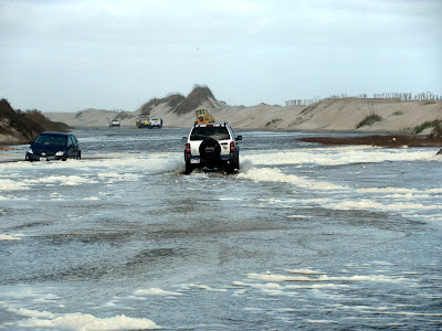
We have this thing about getting safely off Hatteras Island in November. The last time we were here it was a ferry ride with high winds and waves and this time we awoke on our departure day to a coastal flood warning that Highway 12, the only road, could be under water at several places. The first few miles were fine but at the north end of Rodanthe, where the house from the movie used to be, we encountered the first over wash. This was mainly a lot of sand and just a bit of ocean "salt" water, but still very passable. The sheriff there told us that the water was deeper on Pea Island at the "S" turn near the Bonner Bridge but the road was still open. We felt we were committed at this point so we pressed on with the next few miles being high and dry even though we could see several spots were the waves had destroyed the dune and water was rolling through on to the ground along the road. With the bridge in sight we came upon a long stretch of road totally under water. It was shallow enough that we could see the lines to guide us so we did not get into the soft sand on the shoulders. Around another bend we encountered a break in the dune with sand and sea water pouring across the road and one car stuck in the sand with its occupants standing on high ground. Oh well, no turning around now, so we pushed on into deeper water. At least there was a car in front of us so when the lines disappeared we had someone to follow and hope they did not get stuck. All this was three hours before high tide so we knew the water would be getting deeper. Where the road reappeared a park service truck was making all south bound traffic turn around so we were the last vehicle to get through. We were very relieved, but knew we had to get the salt water washed off the rig and car. Fortunately, the rest area on route 64 on Roanoke Island had a dump station so we hooked up the hose and sprayed the salt water off. I am writing this in Myrtle Beach where we gave both vehicles a very thorough scrubbing.
This is the road in Rodanthe. Top right is a wave breaking above the dune. Top left is a break in the dune where the house from the movie, Nights in Rodanthe, used to be. There were waves breaking under several houses along this stretch.
Here we are fording through the water on the north end of Pea Island. This was a little scary, but at least the road was straight here and I could see the lines on the road.
This is the ocean pouring across the road. The car on the left is off the road and stuck in the soft sand. A back hoe was coming to its rescue. The car on the right was the one we slowly followed through the flooded area.
Here is were the south bound traffic was being turned around. We were really happy to be done with this adventure.
Our destination when we left Hatteras was to spend the weekend with Brian & Lori Sharp and their two sons. We watched Brian grow up in WashPA and were here three years ago when we helped them move into their new home. This time we parked in the driveway and had a couple of great relaxing days catching up with what has been going on in their lives. On Saturday we took the ferry to have lunch in Oriental, the sailing capital of North Carolina. We had a wonderful visit and were very happy to be able to spend some time with Brian and Lori and their family.
Andrew and Benjamin. Andrew was only six months old on our last visit and Ben had not been born. They are great kids who just go and go and go.

The Sharps, Brian, Lori, Andrew and Benjamin along with little "Earl" (Grandpap Sharp's chosen nickname) due early next year.

Thursday, November 11, 2010

Changes in Plans, Fishing & Weather

One of the great things about being a fulltimer is the flexibility we have about where we go, when we go and what route we will travel. Sometimes we change plans at the last minute just because we choose to and some times the change is necessary. We added a few days to our stay in Avon so we would be leaving on the weekend. We had planned to spend a couple of days in Ocracoke and then take the ferry to the mainland and stop at Brian and Lori Sharp's to see them and the kids. The last time we were here we went that way and helped them move into their new home. When we checked the weather the day before we were schedule to cross there were high winds, high surf and small craft warnings so we cancelled the ferry reservation and decided we would drive the extra 150 miles to avoid a repeat of that ferry ride on Pamlico Sound. Another change in our plans is that we may get to see a space shuttle launch at Cape Canaveral. The launch scheduled for last month was scrubbed and the new launch date is November 30. This would be great as we missed seeing a launch in 07 when that one was scrubbed.
Another change in plans was having to get the fridge updated as it was recalled. There has been an ever expanding recall of our Norcold model since we have been on the road and ours was finally included. If you have a Norcold you should check the latest recall. We were worried about finding someone out here on Hatteras Island to do the job and were happy to find Bill's RV Service & Repair just up the road in Salvo. Bill ordered the parts and was very efficient in getting the job done. If you are ever in need of a repair on the Outer Banks we would recommend Bill.
The fishing continued to be good but the change was there seems to be bigger fish. I hooked the biggest fish I have ever had here, a very nice drum, that I was able to get to the beach but lost because I was not going into the water, which has cooled down, to pick it up. Oh well I was going to release it any way. I did land this little sand shark. When fishing in Hatteras you never know what you are going to hook. I caught at least eight different species.
Here is a look at how much the weather has changed. Left is looking up the beach from the cottage when Tom & Georgie and Mike & Sheri were here. Right is the same beach today with the high surf. There were many of those rogue waves I warned them about when they were staying there.
Looking down the beach toward the cottage at the Outer Banks Motel. The waves were getting all the way up to the dune. That is a dead deer on the beach, go figure.
Nanc looking at the waves by the circle of stones that mark the old location of the Cape Hatteras Lighthouse. It is a good thing they moved it. The winds today were only about 25 mph with 40 mph gusts, far below the 75mph of the weakest hurricane.
Waves hitting the dunes near the old lighthouse site. The dunes on Hatteras are all man made. They were constructed by the CCC in the 1930's. Before the dunes the high water would just wash across the island into the sound.
Time to head south for warmer weather.

Thursday, November 4, 2010

Outer Banks

For our third week on the Outer Banks the weather continued to be very good with sunny skies and warm temperature. We did our usual beach and fishing thing and did some exploring of the area. When you are here you don't need the GPS to find your way around as highway 12 is the only road up and down the island and there is almost no traffic this time of year. Each day more and more restaurants and stores close for the season. Very few stay open all winter.
Some of you may recognize this house because it was used to film the movie Nights in Rodanthe. It was built in 1980 and was 250 feet from the ocean. By the time it was used in the movie waves were breaking under it at high tide. This past January it was moved to a new, safer location and is once again available to rent. Here is an interesting story about the house.
One place we have never visited in all the years we have been coming to Hatteras Island is the Chicamacomico Life-Saving Station Historical Site & Museum in Rodanthe. This site is dedicated to preserving the history and honoring the men who served in the Life-Saving Service that was the predecessor to the Coast Guard. Ten of the 29 North Carolina stations were on Hatteras Island with the job of rescuing people from ships that ran aground on the shoals of the Graveyard of the Atlantic. Over the years they saved more than 177,000 people. They worked by this quote, "The book says ya gotta go out; it don't say nothin' 'bout coming back!" Above bottom is the surfboat that was used in the 1918 rescue of the Mirlo and a few ship wreck parts found along the beach. Top is a breeches buoy and a beach rescue cart. During the summer months they have a demonstration on how this equipment was used.
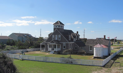
Left is the Midgett House that was the home of Cornelius Payne Midgett and shows a typical Outer Banks home of the early 1900's. Right is the Chicamacomico 1874 station, the oldest in North Carolina. This station was moved five times, three by storms and twice by man.
This is the 1911 station that replaced the smaller 1874 station. It is at its original location and served the Coast Guard, that was formed in 1915, until 1954. During WWII 40 men were stationed here even though it was designed for 8 to 10. The museum is a worthwhile site to visit to get a look at early life on Hatteras Island.
Another site we had not visited since the first time we came to the Outer Banks over 35 years ago is the Wright Brothers National Memorial in nearby Kitty Hawk. We have also visited their home town of Dayton, OH and seen the original Wright Flyer at the National Air & Space Museum in DC. They have an excellent movie that explains all the obstacles Orville and Wilbur had to overcome on their way to flight. Starting in 1900 they travelled to Kitty Hawk each fall to test larger and larger gliders that lead to the 1903 powered flight. Above Nanc cheers Orville on by the 2003 sculpture that celebrated the centennial of this great event.
Center is the monument on the hill in Kitty Hawk where they tested the gliders. Left is the broken original engine that they built from scratch and one of the original propellers. Right is the wind tunnel they constructed to test the designs of various shapes of wings to find the most efficient.
Top left is a reproduction of one of the gliders, center a relief of the brothers with the heading "They taught us to fly." and on the right a reproduction of the original Flyer. Bottom are replicas of the shop and hanger they used on their visits. The large stone on the left was the take off point for the four flights and the the white stones mark the landing spot of each flight they made on December 17, 1903. They took turns piloting the flyer with Wilbur's final flight going 852 feet and lasting 59 seconds. The flyer was damaged on that landing ending the trials for that year. I am always fascinated by how closely in time events and people are connected and this is a great example. My grandfather was five in 1903, I was born two years before Orville died and it was only 66 years after this first flight that we watched the first man step on the moon. This is a very interesting, worthwhile place to visit.
We also travelled over to Roanoke Island to visit Fort Raleigh National Historical Site where the first English colony in the new world was established in 1585. This site is known as the Lost Colony because when the English returned with supplies in 1590 all the inhabitants were gone and the only clue was the word CROATOAN carved on a post. The site also played a role in the Civil War and had a Freedmen's Colony in the 1800's. During the summer there is a play about the Lost Colony. Unfortunately they were working on the visitors center so the reproduction of the small fort above was all we were able to see.
The Bodie Island Lighthouse is undergoing a major restoration. This light is just north of Oregon Inlet near Nags Head and hopefully will be open to the public on our next visit. There are some worthwhile things the government spends money on.
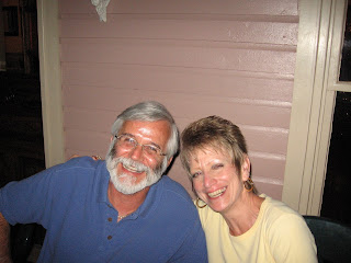
Look at this happy couple out celebrating their 41st anniversary. This is the second time since we have been on the road that we were here for the big day. We had a great meal at the Inn on Pamlico Sound.

Tuesday, October 26, 2010

Enjoying the HI Life

Our second week on Hatteras Island (HI) was filled with sun, sand and friends. Tom and Georgie did a personal mail delivery and spent the week at a cottage at the Outer Banks Motel where we stayed for years when we vacationed here. Mike and Sherri took the ferry from the mainland after spending the weekend with their son Brian's family and stayed with us for a couple of days. It was their first visit to the Outer Banks so we showed them the sights and had a great time on the beach, playing euchre and dining out.
Mike and Nanc on the deck at Tom's and Georgie's cottage that was literally on the water. We always wanted to stay in one of the beach front cottages but they are booked solid in the summer season, the only time we could come here. This picture was at low tide. At high tide we could have fished from the deck. Glad there were no storms or "rogue waves" while they were there.
Sherri and Mike soaking up some of that warm Carolina sunshine.
Georgie, Murphy and Tom. Another advantage of staying in the cottage in the fall is you can bring your dog. We enjoyed spending each day on the beach by the cottage.
The fishing did get a bit better during week two. I caught several including a couple of blues. Look carefully and you can see the fins of two dolphins by my pole.
Murphy had never been in the water before and we "think" he enjoyed taking a dip with Tom.
The ferry Mike and Sherri took landed on Ocracoke, the island south of Hatteras. We met them at the dock then explored this neat little town and had lunch. This is the Ocracoke lighthouse, the oldest in North Carolina.
The British Cemetery on Ocracoke has the graves of the only four sailors whose bodies were recovered when the HMT Bedfordshire was sunk by a German U-boat off the island in May 1942. All others were lost at sea. There is also a British Cemetery on Hatteras Island. At the beginning of WWII the Germans sank so many ships off the Carolina coast that it was known as "Torpedo Alley".
Of course we had to take Mike and Sherri to see the high point of any visit to the Cape Hatteras National Seashore, the lighthouse. At 208 feet it is the tallest in the US. We did not get to the top as it is closed each year after Columbus Day. We did get to see the video about the moving of the lighthouse in 1999. We were here at that time and it was something we will never forget seeing that engineering feat.
Dining out with Tom and Georgie on their last night. Once again, getting the chance to spend time with friends is one of the greatest things about this lifestyle.

Tuesday, October 19, 2010

We'll Cross that Bridge....................

We left DC with the goal of adding Delaware to our state map on our way to the Outer Banks. This route required us to cross two very big toll bridges but since we would be spending a free night at Wally World we decided to go for it.
The first bridge was the William Preston Lane Jr. Bay Bridge which crosses Chesapeake Bay just east of Annapolis to the Eastern Shore and the Delmarva Peninsula. This 4.35 mile bridge rises 186 feet above the water. It was originally just a single span with two way traffic, but a second bridge was added to separate east and west bound traffic. Nanc tells me there is quite a view from the top but I was real focused on the road.
To add Delaware we stayed at the Seabrook Wally World that was just 100 miles from DC. Since we arrived so early we disconnected the car and drove to Rehobeth Beach. We had a nice stroll on the boardwalk and enjoyed the warm ocean air.
The next morning we crossed the Chesapeake Bay Bridge Tunnel. This 23 mile engineering marvel crosses the water where the Atlantic Ocean meets Chesapeake Bay and connects the Delmarva Peninsula with Southeastern Virginia. We crossed it many years ago when there was only one bridge with two way traffic and we were glad to see the newer southbound bridge was wider than the original. It was wide enough that I actually got to enjoy the view as we literally drove across the ocean.
There are four man made islands where the road goes into the two tunnels that were required so there would be no limit on the height of the Navy ships sailing from the base in Norfolk. The tunnels have two way traffic and going through them was just a little intense.
We weren't yet done with the bridges as we had to cross the three mile Wright Memorial Bridge to get to the Outer Banks from the North Carolina mainland. This is another bridge that was once a single two way traffic span but now consists of two bridges. It was a real piece of cake after the previous two.
And finally one last bridge to get us on to Hatteras Island. The Hebert C. Bonner bridge is a 2.5 mile span that crosses Oregon Inlet between the Atlantic Ocean and Pimlico Sound. It has been through several hurricanes and in 1990 a dredge hit it and knocked a section down, isolating everyone on the island until ferry service could be brought in. This bridge is due for replacement because erosion is constantly changing the shoreline. It has two way traffic.
The last part of the trip is down highway 12 on Hatteras Island. Here the road is so close to the Atlantic that it is often covered in water and sand. There are some spots where the island is so narrow that you could hit a nine iron into the ocean on one side and into the sound on the other. That is why we love this place, it is so isolated that you won't find a Wally World or, for that matter, many other chains. We arrived at the Sands of Time Campground to find they were having a fish fry that evening so we joined in and got to meet a few other residents.
To our Pacific coast readers it may be surprising that you can actually go into the Atlantic even in October and not freeze your ### off. The water was fine, the fishing was great, but the catching left a lot to be desired. We are looking forward to a month of just kicking back at the beach and hoping the catching gets better.

Thursday, October 14, 2010

Historic Big Washington -- Part II

One of the greatest things about DC is the beautiful architecture of the monuments and governments buildings. Unlike other big cities the skyline of the city is dominated by the US Capitol and the Washington Monument. The National Mall (open space not a shopping center the 7th graders expected) which runs from the capitol to the Lincoln Memorial (about 2 miles) is the site of several major monuments and 10 of the Smithsonian Museums. We revisited several monuments but did not have the time to explore museums except to see the original Star Spangled Banner that has recently been refurbished.
Without a doubt, for me, the most personal monument is the Vietnam Veterans Memorial known as The Wall. It has the names of the 58,195 service personnel killed in Vietnam. While I did not go to Vietnam during my two years in the Army, I knew several people whose names are on the wall. When it was built many people did not like this "black slash in the ground" so the statue of the three soldiers on the left was added. Later the nurses statue was added to honor the eight women whose names are on the wall. Over time it has become one of the most popular stops in DC. Taking a rubbing (right) of a friend's or relative's name is a common practice here. We did have several students over the years who found their relative's names on the wall. Another practice here is for people to leave personal mementos. We allowed our seventh graders to read anything that was openly displayed but warned them that it could be a letter to a grandparent some child had never met or a note to a buddy someone had served with. On this visit someone had left a Purple Heart and just seeing it was very emotional for me. All these items are collected daily and archived by the park service. Many are displayed in The Price of Freedom: Americans at War exhibit at the National Museum of American History.
At the top are the Korean War Veterans Memorial and the World War II Memorial. These are both very impressive monuments to honor those who served in those wars. The WWII memorial has a wall of 4048 stars each representing 100 Americans who died in that war. In addition to the statues of the soldiers on patrol at the Korean memorial there is a wall of scenes from that war and the words "Freedom is Not Free." Seeing the war memorials in DC really brings that point home. Pictured at the bottom is the Lincoln Memorial and the view from the Lincoln of the Washington Monument and the capitol. The Lincoln has 57 steps, one for each year of his life, and 36 columns, one for each state at the time of his presidency. The statue is very impressive and worth the climb. The trip to the top of the Washington Monument offers a spectacular view of the surrounding area. We did not do it this time. Notice the two colors of stone on the obelisk. The construction was stopped during the Civil War and when it resumed the same stone was not available. It has come to symbolize the split of the war and the joining together of the nation when peace came.
These are the buildings of the three branches of the government. Top are the Supreme Court and the US Capitol and bottom is the White House. The flag is the the Star Spangled Banner that flew over Fort McHenry when Francis Scott Key wrote the poem that became the national anthem. The flag has recently been restored and is on display at the National Museum of American History.
We went to the new Capitol Visitor Center and toured the capitol even though we had done this many times before. Center is looking up at the inside of the dome. The statues are Stephen Foster of Pennsylvania who invented the steamboat, Lincoln and Freedom. Freedom is on the top of the dome and at 19 1/2 feet is the tallest statue in the city as no one should be higher then freedom. Top right is the original Senate chamber that later served as the Supreme Court until their building was built in 1935. Bottom are two of the eight paintings in the rotunda. The visitor center has a display of how the building changed as the nation grew and the workings of Congress. The capitol is a very worthwhile visit.
Above left is the National Archives which has on display the original Declaration of Independence and the Constitution (below left). Seeing these original documents and realizing you are looking at the signatures of the Founders has always been exciting to me. This is a must see. Below right is the Library of Congress and the Gutenberg Bible (top right), one of many rare books that can be found here.
These are pictures of the interior of the Supreme Court and the Library of Congress. This is the first time in my many visits to the city that I have been inside either building. Top center is a statue of John Marshall, the fourth Chief Justice, who lead the ruling that gave the court the power to overturn unconstitutional laws. Bottom right is a model of the justices' chamber. We got there too late to get in line to hear oral arguments in the actual chamber. Something to do on the next visit. The rest of the pictures are the Library of Congress. This has to be one of the most beautiful buildings in the city. They had a display of much of the original library containing the books of Thomas Jefferson. It was a thrill knowing that the books you were seeing had been held and read by Jefferson. We also viewed two special exhibits. One on Ira and George Gershwin which included one of their pianos and several scores of their wonderful music and other memorabilia. The other exhibit was on Bob Hope and his many years of involvement with the USO.
These are the things we saw in our four days in the city. There are many other places that should be on every ones list such as the National Cathedral, Arlington National Cemetery and more of the Smithsonian museums. Everyone should put our nation's capital on their bucket list. It is truly a wonderful place.